")
The GISta Hungarorum database and digital atlas supplemented with data from settlement-level surveys and population census from the 1720s, 1750s (Transylvania) and 1780s was completed under the leadership of the Institute of History of the ELKH Research Centre for the Humanities.
This addition to the existing data series from between 1865 and 1910 provides users with access to socio-economic-demographic data in the format of hundreds of thematic online interactive maps. The name of the digital platform refers to the common English abbreviation for Geographic Information System and to the two historical works recounting the history of the Hungarians entitled Gesta Hungarorum.
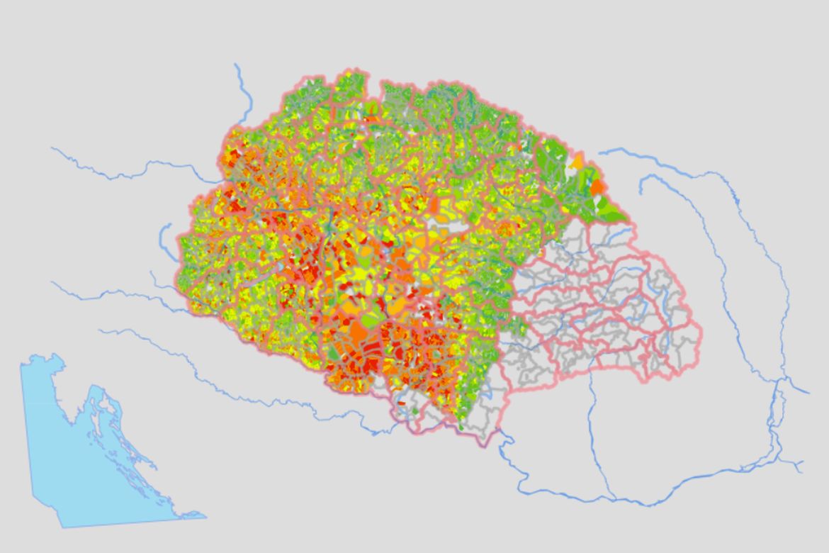
The new project, inspired by the online version of the National Atlas of Hungary created under the leadership of the ELKH Research Centre for Astronomy and Earth Sciences (CSFK), integrates the raw data of the time horizons, which are then displayed in a unified map-based framework on cartograms and in pop-up windows together with socio-economic indicators derived from the basic data. The project was led by Gábor Demeter, a senior scientific associate at RCH Institute of History . The recording of the 18th-century data was carried out with the support of the Momentum Ten Generations Research Group operating at RCH Institute of History. The base maps with a scale of 1:144,000 were created by Gábor Németh, a geographer at the Department of Social Geography and Regional Development Planning of the Faculty of Science and Technology of the University of Debrecen (DE TTK) within the framework of the NKFI “Square Cadastre” (132723) tender program funded by the Hungarian National Research, Development and Innovation Office and headed by T. Csaba Reisz. The development of the WMS (webmap server) implemented as part of the ELKH Proof of Concept program was overseen by Gergő Gyula, managing director of Allum Digital, who is also responsible for the WMS development of Via Mercatoria, another innovation of RCH Institute of History.
When opening the online database, users can click on the button on the upper left side to access the menu bar, which includes the layer that can be switched on and off, the three time planes (18th century, 1865-1910, and 2001-2010), and shows the changes in the peripheries of the three time planes on differential maps. Hundreds of settlement-level maps can be displayed in a thematic system within the time horizons. The grid network for the differential maps was developed by István Papp of the Department of Social Geography and Regional Development Planning of DE TTK, while the 14th-century data was provided by Beatrix F. Romhányi, a professor at the Faculty of Arts and Social Sciences of the Károli Gáspár University of the Reformed Church in Hungary, and the 2001-2010 settlement-level database for the territory of the eight successor states was prepared by János Pénzes, a staff member of the Department of Social Geography and Regional Development Planning of DE TTK and his colleagues, together with Gábor Demeter. The system is currently being test run: the map files and the pop-up menu are continuously being checked and modified.
Expansion of the project to include data from the Middle Ages and Croatia is among the near future plans.
Original article at elkh.org